
Introduction To
Structure Fishing
Identification of Fish Locations
Topics:
- Migration Theory of fish
- Structure types:
- Point Bar
- Underwater Hump
- Channel
- Man Made
- Understanding Breaks & Breaklines
- How to establish trolling patterns
- Structure Fishing Definitions
STRUCTURE FISHING
Buck Perry is considered the grand-daddy of the concept of "Structure Fishing" having coined this term during the 1950's. He's the first fisherman to describe the use of underwater features to locate fish. These ideas incorporated below use his concepts to help identify these structural locations.
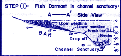
The home of the fish is deep water, where the fish are dormant and very difficult to catch. Periodically, the fish becomes active, and move toward the shallows (food source) using underwater structure as a guide. These bottom features, which go all the way from the deep water to the shallow water, act as submerged highways for the fish during their movement. If we desire to catch fish consistently, we must be able to use these structural features as a guide to the location of the fish.
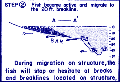
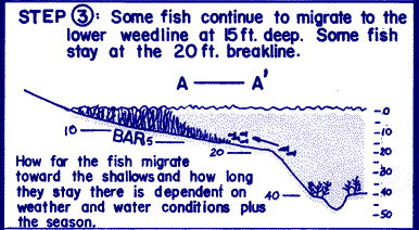
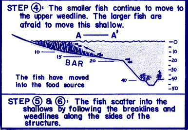
During migration on structure, the fish will stop and hesitate at breaks and breaklines located on structure. We must identify these breaks and breaklines to pinpoint the exact location of the fish. We then present our lures on structure at the correct depth and speed to catch the fish. How far the fish migrate toward the shallows and how long they stay there is dependent on weather and water conditions.
DEFINITIONS
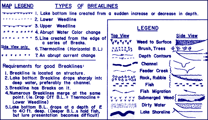
Breaks - Objects found on the lake bottom.
Breakline - An imaginary line on the lake bottom created from a sudden increase or decrease in depth; An abrupt contrast in the underwater conditions ( i.e.: weedline, thermocline, shadeline, water color change, etc.)
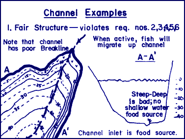
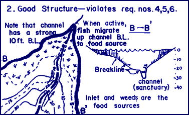
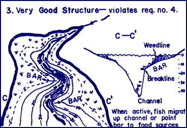
Channel - The submerged riverbed; A type of structure used by fish during migration.
Contact Point - The point at which the fish make first contact with the structure when they start their migration.
Deep Water - 30 ft. deep or deeper; the deepest water in the immediate area, usually the channel; the home of the fish.
Drop Off - A breakline or structure where there is a sudden drop into the deepest water.
Feeder Creek - A submerged gulch, creek, or wash that feeds into the main channel; Structure that fish use during their migration from deep water to shallow water.
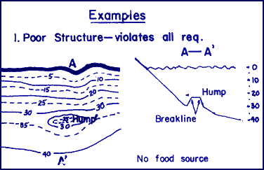
Flat - An area of the lake bottom that contains no structure.
Food Source - An area of the lake that contains food for the fish; Usually an area having either an inlet with running water, a weed flat, rock reef, or a rip-rap, manmade structure.
Hump - An underwater island; A structure in which the lake bottom rises up from the surrounding area.
Migration - A movement of the fish from deep water to shallow water along certain underwater paths.
Migration Route - The actual structure or breakline the fish use during their migration from deep water to the shallows.
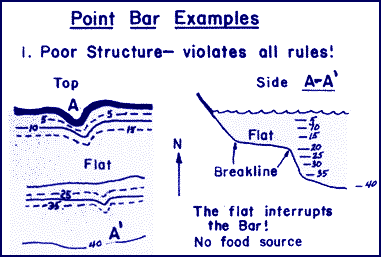
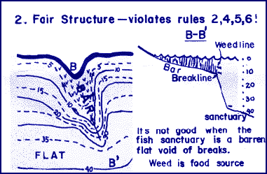
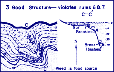
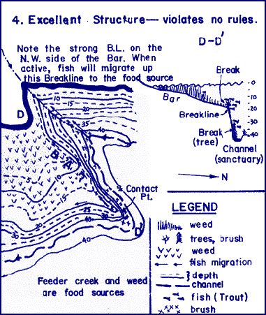
Point Bar - A type of underwater structure in which the shallow water protrudes out into the lake more than the surrounding area.
Ridge - A type of structure where a long narrow hump exists along the sides of a channel or feeder creek; A levee.
Rip-Rap - Large rocks placed by man along the sides of dams and roadways to prevent erosion.
Rock Reef - A type of structure in which the bottom is covered by rock and rubble; A potential food source if found shallow.
Saddle - A type of structure which is formed from two inside bends facing opposite directions.
Sanctuary - An area in deep water where the fish are in a neutral or inactive state; The home of the fish.
Shallow Water - Water with a depth of 10 feet or less.
Shallows - An area containing shallow water.
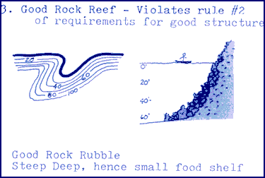
Steep Deep - An area void of structure, which contains very little shallow water due to steep shoreline, drop off conditions.
Structure - A lake bottom feature that is distinctly different from the surrounding area.
Thermocline - a horizontal plane of rapidly changing water temperature.
Weedline (upper) - A line created from the contrast of weed growing to the waters' surface and weed which isn't growing to the surface.
Weedline (lower) - A line created on the lake bottom where the weed stops growing due to depths too great for the weed to grow.
Fishing Strategies
I. Fish Seek Food & Safety-
For consistent fishing success, we must find these two conditions in or lake and present our lures or bait in these areas. Our fishing strategy consists of the following three key steps;
- Find the Food Sources
- Find the Deeper Water (Safety) & other safety features for the fish
- Find the structure connecting the food with the deeper water
- Running water inlet
- Weeds Beds
- Rock Reef
- Large areas of shallow water where light can penetrate to the bottom of the lake.
- Areas of submerged Timber & Brush in shallow water (less than 15' deep)
- Provides safety from surface predators.
- Provides water temperature stability - no rapidly fluctuating temperatures.
- Provides stable light conditions for the fish.
- Weed Beds - Provide cover for the fish in shallow water.
- Submerged Brush & Trees - Provide cover fot the fish in shallow water.
- Rock Reefs - Provide cover for the fish in shallow water if spaces between rockes are large enough.
- Point Bar
- Channels, Feeder Creeks, & Washes.
- Underwater Hump (Submerged Island)
- Rock Reef
- Man-Made Structure (Submerged Roadbeds; Dams, etc.)
Migration Theory of Fish
The home of the fish is deep water, where the fish are dormant and very difficult to catch. Periodically the fish become active and move toward the shallows (food source) using underwater structure as a guide. These bottom features, which go all the way from the deep water to the shallow water, act as submerged highways for the fish during their movement.
Example of fish migration: Point Bar Structure
Top View - Fish: All Trout
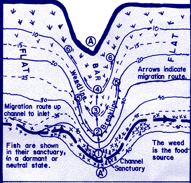
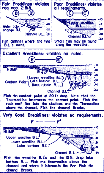
Breaks & Breaklines
Why Breaks and Breaklines are important:
Since the breaklines and structure are the actual migration routes of the fish, and Breaks offer "cover" and location identification for the fish, we must present the lure or bait directly over the Breaks and Breaklines on structure. If the Breakline is located 20ft. deep, we present the lure at 18 to 20ft. deep. When the fish are neutral or dormant, we present the lure or bait over their sanctuary in deep water. Trolling at the proper depth and speed is the fastest way to find the productive Breaks and Breaklines.

Point Bar
Requirements for a good Point Bar:- Point Bar goes all the way from the deep water to the shallow water.
- Top of the Bar has large shallow water area with good food source
- Fish have immediate access to deep water
- Breakline into deep water (Drop Off) occurs at 15-30ft. deep
- Drop off plunges into submerged channel, which has Breaks
- Bar is Large with structural "fingers"
- Drop off faces North (shaded)
- Fish use Point Bars as a guide to go from deep water to shallow water
- Point Bars increase the area of shallow water
- Good Point Bars make the shallow food accessable to deep water
Channel
Requirements for good Channel structure:- Inlet has high water flow. (good food source)
- Food Source adjacent to channel
- Channel has strong Breakline
- Feeder creeks enter channel
- Channel pulls in close to Point Bar, Hump, or Rock Reef
- There are breaks on the channel breakline
- The channel is a natural highway for the fish
- Channel goes all the way from the deep water to the shallows
- The channel is the deepest water in the area and is often the home fo the fish
- The inlet is a food source, assuming water flow
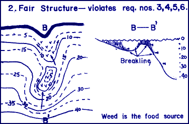
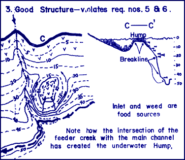
Hump
Requirements for good structure:- The Hump has immediate access to deep water
- Top of Hump is flat & shallow (food)
- Hump is adjacent to channel or creek
- Hump has strong 15-30ft. breakline into deep water
- Top of the Hump is large & has breaks
- Point Bars run all the way from the top of the Hump to deep water
- Humps can provide shallow food source
- Fish use Humps in defining their migration route
- Point Bars are often found with the Hump
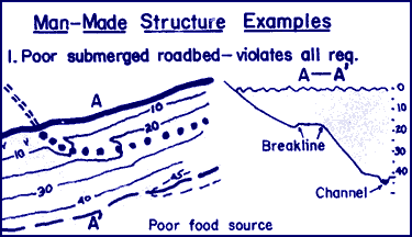
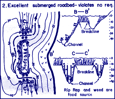
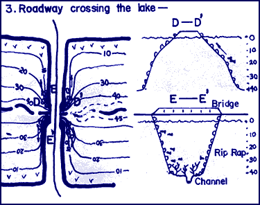
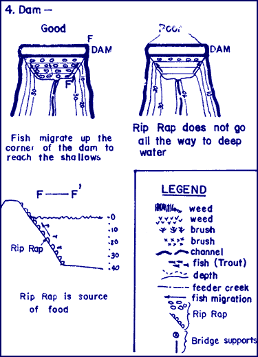
Man Made
Types of Man-Made Structure:- Submerged Roadbed (R.R or auto)
- Roadways crossing the lake
- Dam
- Bulldozed areas
- Goes all the way from deep water to the shallows, which has a food source
- Strong Breakline on the sides of the submerged roadbed
- Crosses the main channel
- Rip Rap covers the Man-Made structure
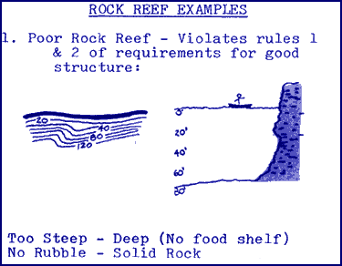
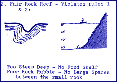
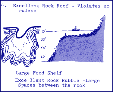
Rock Reef
Types of Rock Reefs- (from poor to excellent):- Solid Rock - Little Rubble
- Small rock of the same size-cobbler type. No spaces between rock
- Rock with undercuts & some rubble
- Rock Rubble - softball to Auto size. Excellent spaces between rocks
- Rock rubble is found in large spaces between the rocks - Plenty of room for fish & small organisms to hide
- Rock Reef covers a large area of shallow water (less than 15' deep.)
- Rock Reef is adjacent to deep water
- Rock Reefs, if found in shallow water, are potential food sources
- Fish use Rock Reefs for safety to hide from other predators
- Rock Reefs can provide a natural migration route from deep water to the shallow food sources
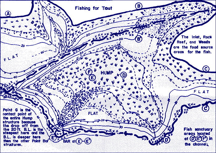
Analysis of a Lake
We will analyze a theoretical lake which is typical of the lakes in California. “Lake Typical” is numbered in various areas, correlating with descriptions below. Each area will be analyzed according to the principals of structure fishing. Conclusions will then be made for the boat and shore fishermen.
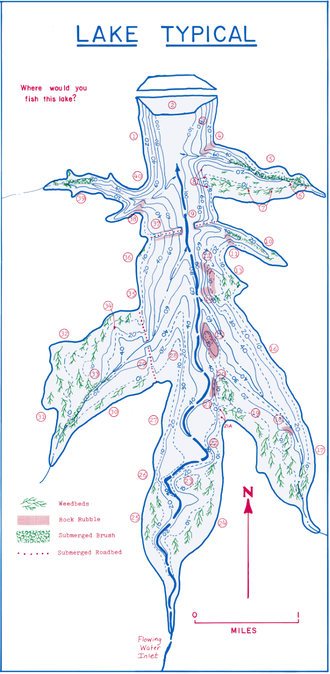
2. If the dam has large rip rap, we might check it out after assessing other areas first.
3. Another rather steep-deep area with no food source nor structure. We will avoid this area.
4. A rapidly dropping rock reef with a small food source area. A few fish will reside here, but they may be large fish. A good smallmouth bass area.
5. The northern side of this bay is not as good as the southern side since it’s too steep-deep. The submerged brush offers potential for finding fish.
6 & 7. Excellent food source area. Troll and cast along the weedline in 8' to 20' depth of water. Note the good breakline at approximately 20' deep. Northern exposure is a plus.
8. Excellent structure next to an excellent food source. A winner! Note how the breakline (drop-off) on the western side of the point bar keeps getting deeper and deeper. Cast and troll along the breakline. However, a western exposure could be detrimental due to the afternoon sun striking the drop-off directly.
9. A submerged roadbed offers structure from the deep water to the shallow. Food source is a problem for this fine structure. Rip rap next to the river is too deep.
10. Feeder creek inlet area with steep sides offers limited food source. Submerged brush increases the potential for food, but we aren’t enthusiastic about this area.
11. Rock reef has limited surface area in the shallow water; hence limited food source. We will check it out since this area is located near another food source (See #10).
12 & 14. Excellent rock reef structure with food source in the rock and adjacent weedbed.
13. Weedbeds can provide good fishing for the shore fisherman, especially in the small feeder creek.
15. Another excellent rock reef offering a food source with excellent structure and breaklines at various depths. The underwater hump must be checked carefully on both sides since exposure to the sun could be critical.
16. This entire shoreline is probably a waste of time. Steep-deep enough so that there’s very limited food and no structure.
17. Inlet area offers a weedbed. Troll and cast along the weedline. A potential area for the shore fisherman where the weed dissipates along the shoreline.
18. A rock reef next to a food source (weeds) and deeper water (channel). Possibly a real honey hole. Breakline may be too shallow at less than 10', but northern exposure helps (low light).
19. Troll the weedline.
20. Top of point bar next to a weedbed food source offers encouragement.
21. Rock reef next to channel and weedbed food source is a potential hot spot. Point bar breakline.
21A. Possible bonanza for the shore fisherman. Breakline into deep water next to food source is a winner.
22. Curving channel may have formed a hole and undercut banks next to an adjacent food source. Potential shore fisherman’s delight.
23. Underwater hump next to food source (weeds, inlet and channel) offers excellent potential.
24 & 25. Fish weedline adjacent to channel.
26. Another curve in the channel next to a food source. A potential bonanza.
27. Somewhat steep-deep with no food structure – ugh!
28. Excellent point bar structure, but limited food source. We hope to be pleasantly surprised.
29. Submerged roadbed offers structure. Limited food source with weedbed at large point bar. We’ll check it out.
30. Simple weedbed but no adjacent deep water or structure.
31 & 32. Massive weedbed offers a huge food source for food potential. Fish the weedbed next to the channel and submerged brush.
33. Edge of small hump next to channel offers excellent potential. We must check it out.
34. Deep water pulling in next to a weedbed could be a hot spot, especially since it’s a feeder creek.
35. Steep-deep, no good.
36. Limited food source and structure.
37. Submerged roadbed offers some potential since there is rip rap on both sides of the former road.
38. A rock rubble reef at the mouth of a small cove having weeds and brush offers some fishing potential.
39. Small cove having weedbeds and submerged brush offers limited fishing potential due to the small size of the food source.
40. Point bar at mouth of cove, having no rock rubble, has limited potential for fish.